Tuesday, November 21, 2006

In the News: The Coastline Is Retreating. Should the Montauk Lighthouse Stand Its Ground?

The debate rages on in Montauk regarding its charismatic lighthouse and how to address the ever-encroaching coastline below. Since the structure was built in 1796 (commissioned by George Washington no less!) the buffer between the sea and the towering lighthouse has shrunk 
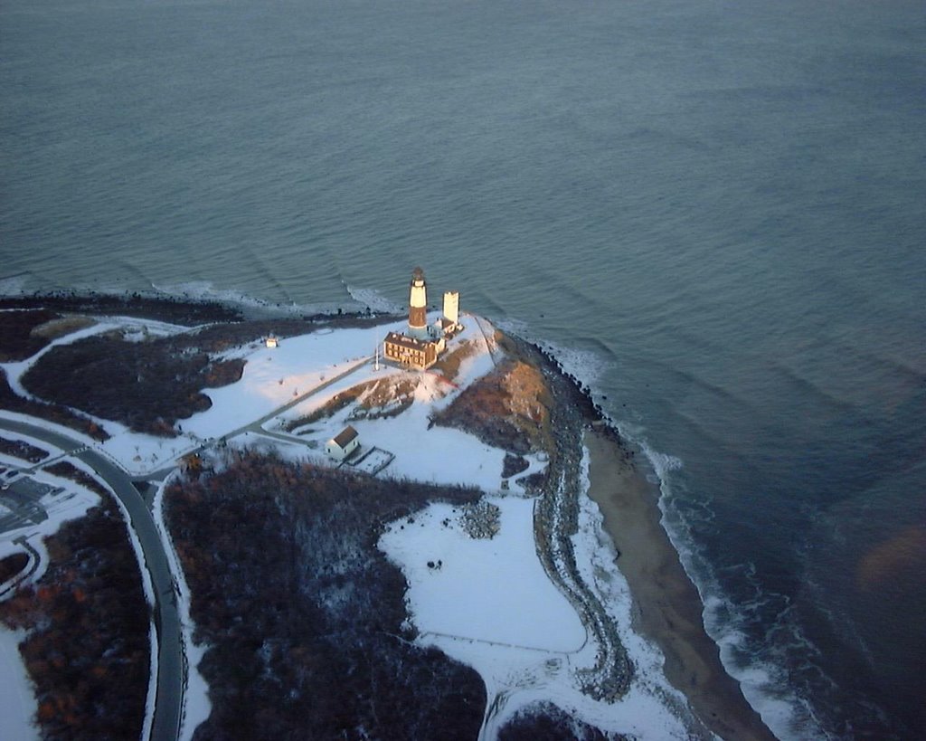
from a generous 300 feet to a precarious 75. Now coastal managers, fisherman, surfers and local residents are left to decide whether to retreat or stand their ground...JB

Photo: Anders Brownworth (www.anders.com)

By Cornelia Dean
November 21, 2006


Lighthouses speak to the imagination. They illuminate the darkness, remind us of a vanishing maritime heritage and embody what it means to make it safely home.

So when erosion threatens to send a lighthouse toppling into the sea, people want to save it. But how? The way we answer that question involves more than engineering. It can become a statement about how we intend to live with our eroding coasts.

Read more:
http://www.nytimes.com/2006/11/21/science/earth/21comm.html

Video:
http://nytimes.feedroom.com/?fr_story=4db4f0511aac94767acc5b17838c7ab8d2600bfe

More on the Lighthouse Debate
http://travel2.nytimes.com/2006/11/14/nyregion/14light.html

Google Map of Montauk Lighthouse
http://maps.google.com/maps?f=q&hl=en&q=montauk&sll=40.694038,-73.999283&sspn=0.013796,0.019226&ie=UTF8&z=12&ll=41.058903,-71.899338&spn=0.109764,0.21492&t=h&om=1

Montauk Lighthouse
http://www.montauklighthouse.com/home.htm

Wikipedia - Montauk Lighthouse
http://en.wikipedia.org/wiki/Montauk_Point_Lighthouse

Thursday, November 16, 2006

CMRC Winter Waterfront Luau - Tuesday, December 19th

CMRC WINTER WATERFRONT LUAU ~~~ SAVE THE DATE!!!

Join the CMRC in celebrating a “superfine” year in coastal conservation. Drinks, food and some waterfront cheer.

CMRC WINTER WATERFRONT LUAU* Tuesday , December 19th ~~~ 6:00 – 8:00 PM* Superfine, Dumbo, Brooklyn (Map Link Below) * RSVP To: info@thecmrc.org

Details to follow. For more information please visit us at http://www.thecmrc.org/

http://maps.google.com/maps?f=q&hl=en&q=superfine&sll=40.694038,-73.999283&sspn=0.013796,0.021157&ie=UTF8&z=14&ll=40.70797,-73.993778&spn=0.027587,0.042315&t=h&om=1&iwloc=A

Wednesday, November 15, 2006

CMRC Virtual Estuary Project Now Online!!!

The CMRC's Virtual Estuary Project is an effort that aims to bring the experience of our coasts and waterfronts to residents throughout the NY-NJ region by using technology and media to convey the story of our coastal habitat, species and communities. We are proud to unveil the Virtual Estuary for the first time today at www.virtualestuary.org!

Please stay tuned for frequent updates and feel free to contact us at virtual.estuary@thecmrc.org with ideas, links or questions.
JB

Virtual Estuary Project Overview
The Virtual Estuary Project is an initiative that uses cutting-edge technology and interactive media to create an educational tool that explores the natural resources found within the coastal environment of the New York – New Jersey Harbor Bight.

Project Background
The Harbor Bight is home to one of the largest metropolitan regions in the world. It includes a population of 22 million residents, thousands of academic institutions and an international business community. Unfortunately, the extent of the region’s development puts tremendous stress on the health of the estuary's natural systems. The Virtual Estuary aims to reconnect residents with the coastal ecosystem through a variety of interactive educational tools that increase awareness regarding aquatic species and habitats while simultaneously conveying important conservation lessons to individuals and entire classrooms.

Virtual Estuary Overview
The Virtual Estuary Project is a partnership between the CMRC, Key East Consulting and Fallout Pictures that allow users to experience the Harbor Bight ecosystem through the use of computers and media players. Located at
www.virtualestuary.org, the website offers access to web-based media via multiple gateways. The primary interface will resemble Google’s mapping program (www.maps.google.com) and will include highlighted links to site specific media that showcases a variety of coastal features and topics such as: aquatic species, coastal habitat, waterfront communities and maritime history. It will be accessible first online where information will be downloadable to desktop computers and portable devices and then in a DVD format that will be distributed to after-school programs.

The Virtual Estuary Project includes the following components:

  • Online Map and Searchable Content Interfaces
  • Interactive Species and Habitat Modules
  • Downloadable “Flash” Videos and Podcasts
  • Web-Based Educational Games

By allowing residents to learn about the different species, habitats and coastal communities users will gain a better understanding of the resources and challenges facing our coastlines. Students and teachers will be able use the information to discover the ecology and maritime history of our region. Local residents will be able to experience the Harbor Bight in a new way by exploring our ecosystem and gaining knowledge through easily accessible cutting-edge technologies.

For more information please email virtual.estuary@thecmrc.org

Thursday, November 09, 2006

In the News: LI's wetlands are key to marine health

One of the biggest changes to our coastal landscape has been the significant loss of marine habitat to shoreline alteration. Historic maps of the region clearly show that thousands of acres of marshes and submerged lands have been lost (Health of the Harbor, pg 10). The end result, as reported in a recent issue of Science Magazine, is greatly reduced fisheries abundance and species diversity. In order to allow these species to recover, we must begin the costly process of restoring the miles of bulkheaded, filled and hardened shorelines to their natural state...JB

By Jennifer Smith
November 2, 2006

From the crash of the Great South Bay's once-abundant hard clam population to the near disappearance of eelgrass from the bottom of Long Island Sound, Long Island's coastal waters are no strangers to species loss.

This week a study in the journal Science took a larger look at how the loss of aquatic biodiversity -- the total number of fish and plant species in a habitat -- affects the ecosystems that nourish marine species.

In coastal areas, the study linked the regional loss of biodiversity with a decline of viable fisheries and impaired "nursery" habitats such as wetlands and seagrass beds, which shelter young fish.

Read more:
http://www.newsday.com/news/local/longisland/ny-hsloca1103,0,76050.story?coll=ny-longisland-homepage

Additional Coverage in Newsday - "Stability of marine life in severe danger"
http://www.newsday.com/news/health/ny-hssea1103,0,4706897.story?coll=ny-leadhealthnews-headlines

Op-Ed in NY Times - "The fishing industry lobbies Congress for the right to overfish. "
http://www.nytimes.com/2006/11/05/opinion/nyregionopinions/05LI-mcmurray.html

Image A - Crab Meadow, LI
Image B - RPA Map of Wetland Losses